
Take A Hike: Ouray Perimeter Trail

Photos by Melanie Wiseman.
Collaboration is amazing when it works. And, it’s definitely working in Ouray, Colorado. The Ouray Perimeter Trail is a joint project of Ouray Trail Group, the City of Ouray and the U.S. Forest Service. Not your typical loop, Perimeter Trail is a unique, moderately challenging, 6.5-mile hiking experience featuring varied terrain, unparalleled scenery, cliffs, four waterfalls, five bridges, a tunnel, deep gorges, wildlife and up-close geology — all while circumnavigating the “Little Switzerland of America.”
The best time to visit the Ouray Perimeter Trail is May through October. My excursion happened at the end of May with plenty of wildflowers lining the trail, water flowing rapidly and deer eating fresh spring grass right next to the trail. Take into consideration that it takes a while each day for the sun to rise over the San Juans and touch the trail and town when deciding when to start this hike.
Ouray Perimeter Trail is a great trail for kids and dogs, as well as adults of all ages. Be sure to wear sturdy shoes or boots, and don’t forget your hiking poles. One very popular feature of the Perimeter Trail is it’s never more than 500feet vertically or 1/2 mile horizontally from Ouray’s city limits. As a result, there are several locations along the route where hikers can opt for a shorter version and return to town without having to hike its entire length.
The trail starts at 7,700 feet, with the highest point being 8,500 feet, and has an elevation gain of 1,600 feet. Allow four hours for the hike, so you have plenty of time to enjoy the many scenic spots and a picnic lunch. Carry a trail map with you due to the many connected fragments of the trail. Ouray Visitor’s Center has a Perimeter Trail pamphlet containing a trail map. However, the larger map found in the official visitor guide is the better option.
THE TRAIL
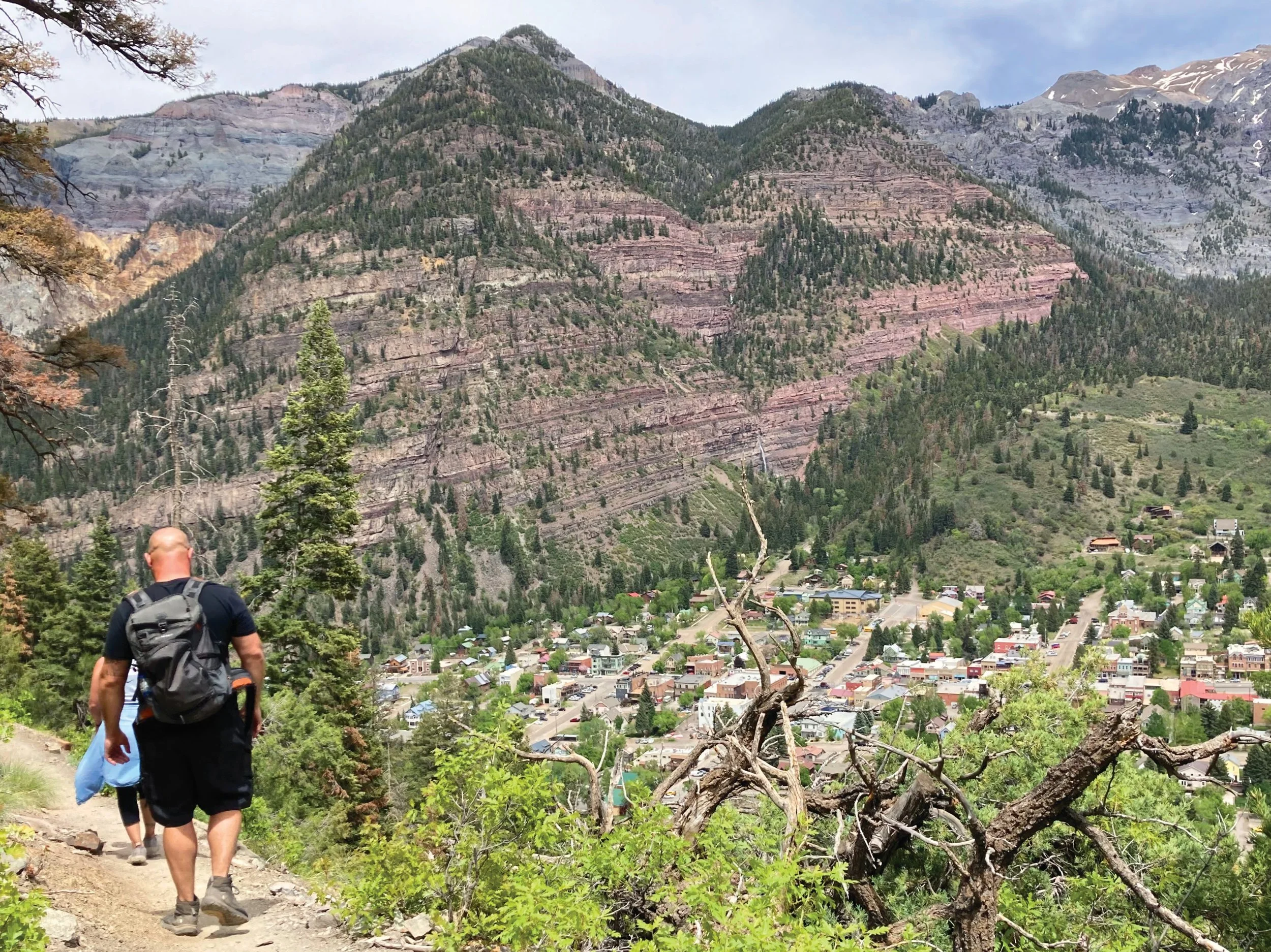
Although there are many spots around town where you can begin this loop hike, the most common starting point is the Ouray Visitor’s Center on the northwest edge of town next to the Ouray Hot Springs. Plenty of free parking is available, and you’ll want to pop inside for a map.
I concur with locals to hike the loop in a clockwise direction, as navigation is much easier. From the Visitor Center, cross U.S. 550 where your adventure begins with a set of railroad-tie steps. A sign will point you along a gravel path just before the trail begins ascending the hillside and another set of railroad-tie steps. The first 2/3mile of the trail is the most difficult, with a series f steep climbs followed by a narrow stretch along a cliff face.
You’ll soon enjoy outstanding views of Main Street and 11,475-foot Hayden Mountain towering over the south end of town. Cascade Falls is the first up-close-and-personal experience. This waterfall is the lowest in a series of seven waterfalls, as Cascade Creek runs down Cascade Mountain. Spring and early summer are normally the best times for viewing the waterfall when water volumes are much higher.
Cross the footbridge over Cascade Creek, and after a short steep climb, the trail becomes less strenuous and exposed. At 1.3 miles, the trail encounters Amphitheater Campground Road. Do not continue to the trail directly across the road, but turn right and follow the road a short distance, .12 miles, then turn left onto the Baby Bathtubs Trail to continue on the loop. Hikers will enjoy viewing water dancing through a series of several small rock “bathtubs” carved into the stream bed.

At 1.7 miles, hikers reach the Portland Trail junction; cross a footbridge and travel another0.2 miles to reach County Road 16. At just 50yards up the gravel road, the trail forks off to the right through a beautiful grassy field with spectacular views of the Million Dollar Highway and the surrounding mountains. This section travels over the highest point on the trail and is considered the most scenic.
Cross U.S. 550, and follow a wooded dirt road to a bridge crossing over the Uncompahgre River near one of the premier ice climbing spots in the world and the Box Canon Park. Stay left, and cross the Box Canon High Bridge spanning the spectacular Canon Creek Gorge. Immediately after the bridge, you’ll pass through the old Ouray water tunnel.
At this point, the trail appears to drop you into town, but additional land has been acquired, extending the journey. When the trail does bring you back to town, follow Oak Street north to the City’s Maintenance Shop, cross the footbridge on the right and return to the Visitor Center where you began.
A soak or swim in the Hot Springs Pool is a great way to round out the day!
Originally published in the Summer 2023 issue of Spoke+Blossom.